Pallikaranai Ramsar Site
One running record of the Pallikaranai marsh in Chennai: how it was designated, the NGT order and CMDA approvals freeze that followed, and the Madras High Court case now deciding where the zone of influence ends. Dated entries, primary documents and maps, updated as the position changes.
Three boundaries, three different sizes
Most confusion about this site comes from mixing up three separate lines on the map. They differ in what they are, how large they are and how firm they are.
| Boundary | What it is | Extent | Status |
|---|---|---|---|
| Ramsar site | The notified wetland, Ramsar site no. 2481, designated 8 April 2022. | 1,247.5 ha, across seven revenue villages | Notified |
| 1 km influence area | The zone drawn on the map enclosed with CMDA Office Order 07/2025, following the NGT order of 24 September 2025. CMDA has been told not to grant approvals here. | A continuous band around the site, running through about 15 villages on the map | Last order seen |
| Proposed interim zone of influence | The Wetlands Authority's revised proposal to the High Court, filed 9 October 2026. Individual parcels, mostly along the marsh edge. | 36 survey numbers, about 128.19 ha | Proposal only, described as interim |
2022–2024: Designation and the NGT case
-
8 April 2022Pallikaranai Marsh becomes a Ramsar site
The marsh is designated a wetland of international importance under the Ramsar Convention, listed as site no. 2481 (Pallikaranai Marsh Reserve Forest) with an area of 1,247.5 hectares, about 3,000 acres. The notified boundary lies in seven revenue villages: Perumbakkam, Sholinganallur, Pallikaranai, Perungudi, Jalladianpet, Injambakkam and Okkiyam Thoraipakkam.
-
30 June 2023NGT opens a suo motu case
A news item in The New Indian Express, “Road being laid inside marshland in Perumbakkam”, reports a private builder laying a road across the marsh by dumping construction material. The National Green Tribunal's Southern Zone takes the matter up on its own motion as Original Application No. 91 of 2023 (SZ). This is the case that produces the 2025 order.
-
Jul – Sep 2023First reports to the Tribunal
DTCP reports on 31 July 2023 that the Perumbakkam marshland falls under CMDA, which replaces DTCP as the respondent. Revenue officials inspect the site on 7 August 2023, and the Chengalpattu District Collector's report of 22 September 2023 says a building and road were being built on marshland owned by the Forest Department.
Official: NGT order, paras 4–5 and 10 -
2024CMDA says it lacks the survey details
In reports dated 17 January, 6 May and 19 August 2024, CMDA says it granted approvals on the basis of revenue records and the Second Master Plan, and that it entertains no application on land earmarked as Pallikaranai Swamp Area in that plan. It adds that it has not received survey numbers or influence-zone details for the Ramsar site from the Tamil Nadu State Wetlands Authority, which had shared only a boundary shapefile after a meeting on 1 April 2024. CMDA asks the Authority for the survey list by letter of 8 August 2024.
Official: NGT order, paras 6–8
2025: The NGT order and the CMDA freeze
-
10 July 2025Wetlands Authority and CMDA file updated reports
The Wetlands Authority tells the NGT that the earlier Integrated Management Plan (IMP), prepared by Care Earth Trust, marked a general zone of influence of 1 km from the marsh boundary. It adds that, because of patta lands and heavy urbanisation, it would be prudent to delineate the zone from inlet and outlet channels and satellite wetlands in the catchment, as part of preparing a new IMP, and that the zone would take effect only once that IMP is approved.
CMDA's additional report records that the Authority has identified 304 survey and subdivision numbers in the Ramsar site across the seven villages, with details CMDA calls approximate, and that CMDA has issued no planning permission in land earmarked as Pallikaranai Swamp Area in the Second Master Plan.
-
24 September 2025NGT order in O.A. No. 91 of 2023 (SZ)
The Southern Zone bench of Justice Pushpa Sathyanarayana (Judicial Member) and Dr. Prashant Gargava (Expert Member), after reserving judgment on 1 September 2025, disposes of the case with these directions:
- “Until the preparation of the IMP is completed, the authorities shall not grant any approvals, sanctions, or permissions that may alter the character of the marshland.” (para 44)
- Any approval on the marshland and its zone of influence can be granted by CMDA only after the IMP is prepared, based on the Wetlands Authority's survey. (para 45)
- The Water Resources Department, the Wetlands Authority and CMDA are to coordinate to expedite the IMP. (para 46)
The order notes the 1 km zone of influence recommended in the earlier IMP, and records the Water Resources Department's report of 29 August 2025 that the National Centre for Sustainable Coastal Management is revising the IMP under the Wetlands (Conservation and Management) Rules, 2017, with the zone of influence to be delineated in it and effective only once the updated IMP is approved.
-
9 October 2025 (effective 6 October)CMDA Office Order No. 07/2025
CMDA gives effect to the NGT order. The order records that the Tribunal “has ordered ‘the authorities not to grant any approvals/permissions in the RAMSAR Site boundary and its zone of influence of 1 km’”, and instructs officers “not to grant any approvals/permissions in the RAMSAR Site boundary and its influence area as per the map enclosed herewith.” It takes effect from 6 October 2025.
The text deals with approvals CMDA may grant. It does not mention existing buildings, sale or registration of property, or bank loans, so it does not answer those questions either way.
2026: The Madras High Court case
-
Before July 2026CREDAI Chennai challenges the NGT restriction
CREDAI Chennai, with Olympia Tech Park (Chennai) Private Limited and Navin Housing and Properties Private Limited, files W.P. No. 7120 of 2026 in the Madras High Court. The respondents include CMDA, the Chengalpattu District Collector, the Department of Environment and Climate Change and the Tamil Nadu State Wetlands Authority. The petitioners call the 1 km restriction unscientific, point out that the adjoining areas are already urbanised, and suggest a zero-kilometre buffer for such areas. They also ask for a stay. About a dozen related writ petitions are tagged with it.
Sources: DT Next · Status Report in W.P. No. 7120 of 2026. Filing date not seen. -
Mid-July 2026 (reported 16 July)First Bench hears the matter
The First Bench, Chief Justice S.A. Dharmadhikari and Justice G. Arul Murugan, adjourns the final hearing to 3 August. The State tells the court that, because of the NGT order, planning-permission applications cannot be processed and 47 are pending. No stay or other interim order is reported.
Source: DT Next -
4 August 2026Court asks the Wetlands Authority for a proposal
By its order of 4 August the court directs the Tamil Nadu State Wetlands Authority to report on a proposed interim zone of influence. The Authority files an earlier status report in compliance.
Source: Status Report dated 9 October 2026, para 2. The order itself is not published at a public link we could find; see Official records. -
7 September 2026Representations to be considered
After the petitioners make suggestions in court, and after the Authority receives 23 representations from landowners, developers and others around the site, the court's order of 7 September leads to a consultation on reworking the zone. The representations ask for four things: exclusion of privately owned patta land, reconsideration of particular survey fields, recognition of existing developments and permissions, and rules that distinguish the wetland boundary, the zone of influence and developed private land.
Source: Status Report dated 9 October 2026, paras 3–4 -
30 September 2026Consultation meeting
The Authority meets officials and technical agencies and re-examines each parcel for hydrological connectivity, drainage pathways, satellite wetlands, existing infrastructure, land use and the wetland-urban interface, using historical Google Earth imagery to check water spread, low-lying areas, drainage channels and built-up land.
Source: Status Report dated 9 October 2026, para 4 -
9 October 2026Revised interim zone of influence filed
The Member Secretary of the Tamil Nadu State Wetlands Authority affirms a Status Report proposing an interim zone of 36 survey numbers covering about 128.19 hectares that “can likely have an impact on the hydrology” of the site. Its position is that construction need not be absolutely prohibited across the zone but regulated on site-specific scientific and hydrological grounds. Proposed safeguards inside the interim zone:
- No blocking, diversion or obstruction of inlet and outlet channels, natural drains or hydrological pathways.
- No dumping of solid waste or construction and demolition waste in drainage pathways.
- No discharge of untreated sewage or effluent into watercourses connected with the wetland.
- No permanent alteration of established hydrological connections.
- No Red Category industries with high pollution potential.
- For construction, a No Objection Certificate from the District Level Wetlands Management Committee under the proposed regulatory mechanism.
The report calls this an interim arrangement, not the final delineation. The final zone is to follow scientific and cadastral exercises and ground-truthing under the Wetlands (Conservation and Management) Rules, 2017.
Source: Status Report in W.P. No. 7120 of 2026 (no public link found; see Official records) · Survey numbers · Maps -
12 October 2026Hearing listed; outcome not seen
The bench had adjourned the matter to 12 October. Press reports on 13 and 14 October describe the Authority's proposal as covering about 316.76 acres (the same extent as 128.19 hectares) across 36 survey numbers, excluding private patta lands. We have not seen what happened at the hearing.
Press: DT Next, 13 October · DT Next, 14 October
Official records
Direct links to the court, tribunal and government records behind this page. Where a record is not published online at a direct link, the portal and the case number to search are given instead.
NGT order, 24 September 2025 GOV.IN
Judgment in Original Application No. 91 of 2023 (SZ), National Green Tribunal, Southern Zone, Chennai. 19 pages.
Open on greentribunal.gov.in →Wetlands Authority report to the NGT GOV.IN
Status report of the Tamil Nadu State Wetland Authority in O.A. 91 of 2023 (SZ), filed 11 July 2025, with annexures.
Open on greentribunal.gov.in →CMDA additional status report to the NGT GOV.IN
Additional status report of the Chennai Metropolitan Development Authority in O.A. 91 of 2023 (SZ), dated 10 July 2025.
Open on greentribunal.gov.in →CMDA Office Order No. 07/2025 GOV.IN
Two-page order dated 9 October 2025, effective 6 October 2025, with the influence-area map enclosed.
Open on cmdachennai.gov.in →NGT: find any filing in the case GOV.IN
National Green Tribunal website. Use its case status search for Original Application No. 91 of 2023, Southern Zone (Chennai) to see the full record.
Open greentribunal.gov.in →Madras High Court: W.P. No. 7120 of 2026 GOV.IN
We have not found the orders in this writ petition published at a direct link. To check the latest orders and listing, search case type W.P., number 7120, year 2026 on either court portal.
The High Court's orders of 4 August and 7 September 2026 and the Wetlands Authority's Status Report of 9 October 2026 are described here from the Status Report itself. They will be linked as soon as a public copy is available.
Survey numbers in the proposed interim zone
Listed in the 9 October 2026 Status Report. All are in Sholinganallur taluk, Chennai district, except Perumbakkam (Tambaram taluk, Chengalpattu district). “(P)” means part of the survey number. Match village and number together, since the same number can exist in several villages, and check the sub-division against the patta.
Show the 36 survey numbers by village
| Village | Survey numbers |
|---|---|
| Injambakkam | 283; 284(P) |
| Karapakkam | 175(P); 177; 189 |
| Okkiyam Thoraipakkam | 407(P) |
| Pallikaranai | 23 (1A, 2); 55 (1D2, 1E2, 1F2, 1G2, 2A2, 2B2, 2C2, 2D2); 80; 429/2; 429/3; 430; 431/2(P); 432/1; 433; 434/3; 453/2C; 657 (1A, 3A1, 3A3, 3A4, 3F, 3G, 3H, 3I, 3J, 3K, 4A3); 657/1A(P); 657/1B3; 657/3A2, 3B; 657/3A3; 657/3A5; 657/4C; 658/1A(P); 658/1B; 688(P); 690(P); 691 |
| Perungudi | 57/1 |
| Sholinganallur | 439(P); 507/1; 527; 602/7 & 8 |
| Perumbakkam | 537(P); 542(P) |
Transcribed from a scanned annexure, so check it against the filed report or the Wetlands Authority before relying on it for a transaction. The proposal is not adopted, so being on or off this list does not change a parcel's position under the CMDA order.
Maps & documents
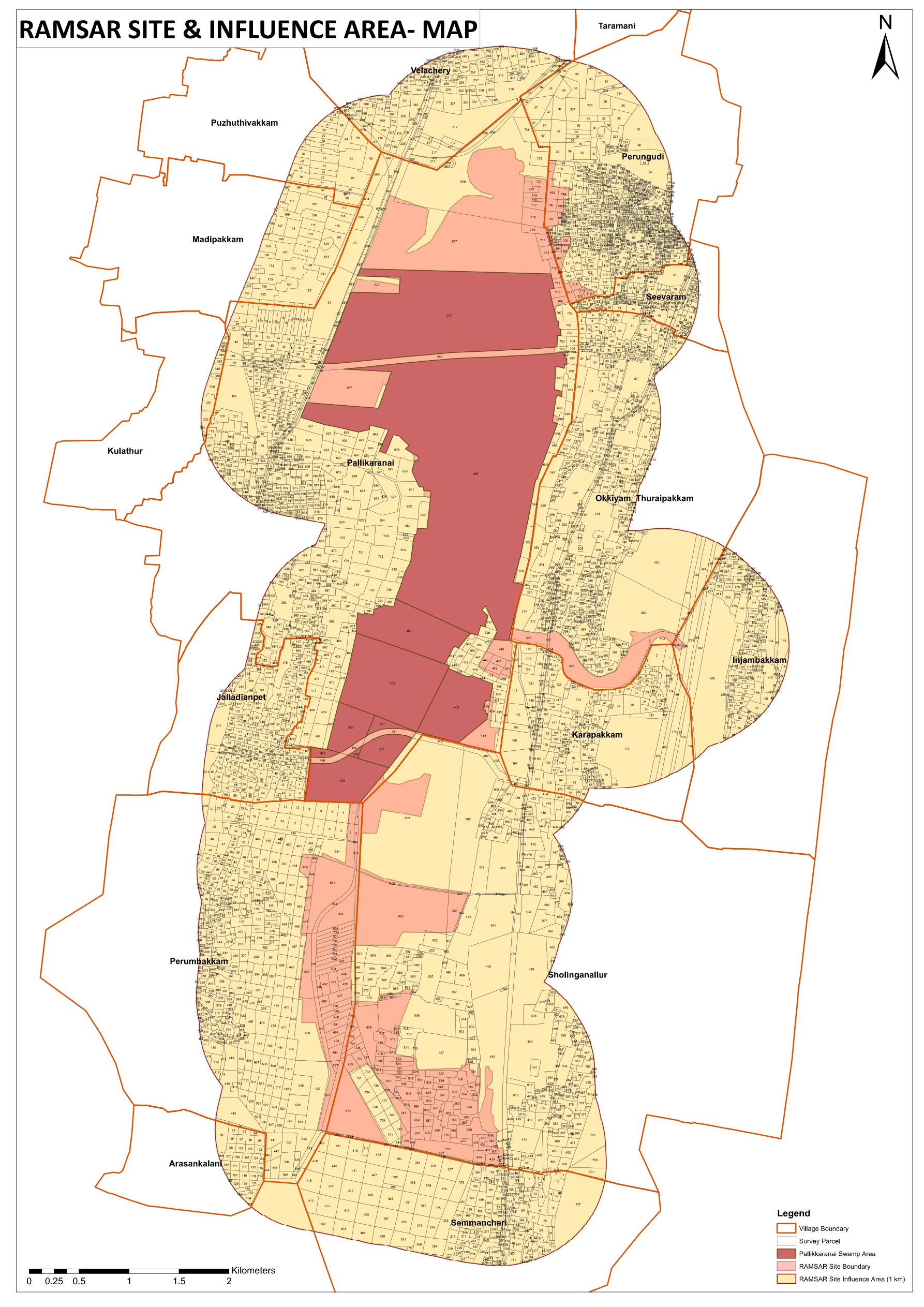
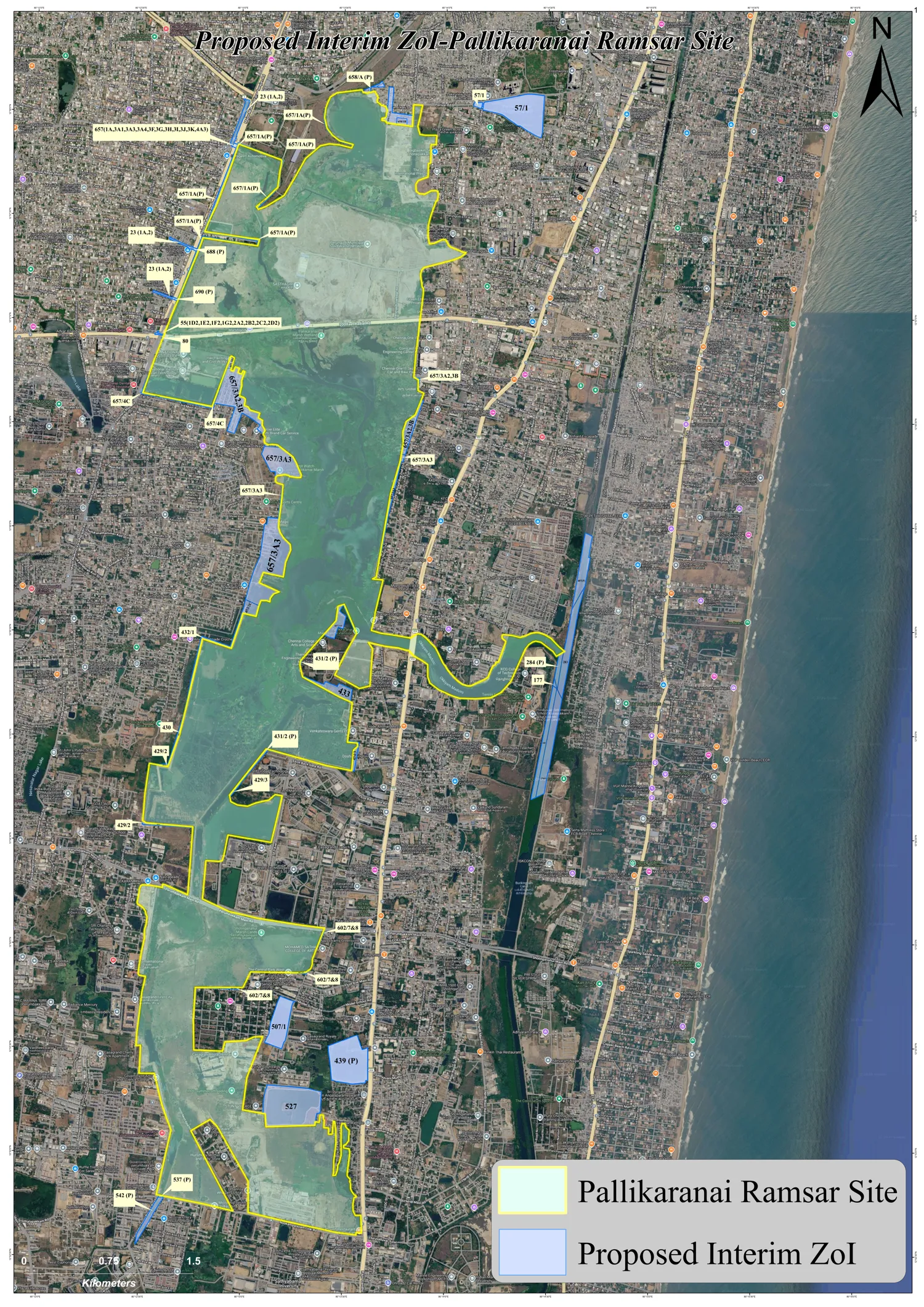
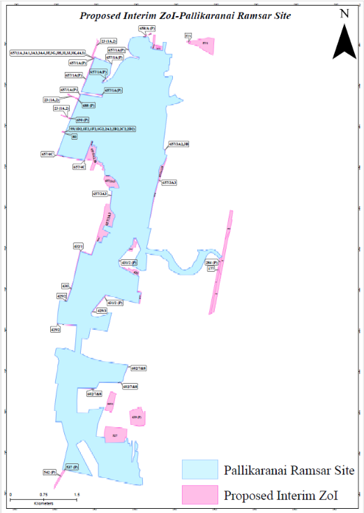
CMDA Office Order No. 07/2025 GOV.IN
Two-page order dated 9 October 2025, effective 6 October 2025, with the influence-area map enclosed.
Ramsar site & influence-area map (PDF)
The CMDA map over village and parcel boundaries, at a size you can zoom to find a survey number.
Download map →Checking a parcel: read the village and survey number off the patta or sale deed, find the village on the maps, and match the number within it. If a parcel sits on an edge or cannot be read with confidence, treat it as unconfirmed and ask CMDA or the Wetlands Authority for a written reply. The interactive map below is a useful second reference.
Still undecided
- The updated Integrated Management Plan is not out. The NGT order ties approvals to its completion, and the Water Resources Department told the Tribunal the zone of influence will take effect only once the updated plan is approved.
- The court has not adopted the proposal. The Authority itself calls it interim. A parcel on the 36-number list is only proposed to be in the interim zone.
- The CMDA order is unaddressed. The Status Report does not say whether CMDA will withdraw or amend its 1 km order, or when. Parcels outside the 36 numbers but inside the yellow area on the CMDA map remain unconfirmed until CMDA or the court says so in writing.
- The NOC mechanism is not described. The report mentions an NOC from the District Level Wetlands Management Committee but not how it would work or how it fits with CMDA's order.
- The final zone is still to come. It depends on scientific and cadastral exercises and ground-truthing under the Wetlands (Conservation and Management) Rules, 2017.
- Existing buildings, sale, registration and lending are outside the text of the CMDA order. Banks and registration offices set their own approach.
Official sources & press coverage
Ramsar Sites Information Service OFFICIAL
The international record for the site: designation date, area and ecological description (site no. 2481).
Open RSIS record →TN Wetlands Authority: interactive map GOV.IN
GIS viewer for checking a parcel against the notified wetland boundary.
Open map viewer →TN Wetlands Authority: site information GOV.IN
The state authority's profile page for Pallikaranai Marsh Reserve Forest, plus its Ramsar Convention page.
Press coverage
Used only where no official record is online, mainly for the High Court hearings. News reports can differ in detail from the orders themselves.
Spotted an error or a newer order? Email the official source link to propref.in@gmail.com.
Related Glossary
Ramsar Site · Zone of Influence · NGT · CMDA · Survey Number · CRZ